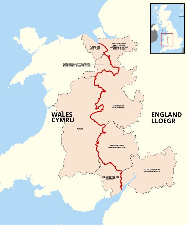
Here in the UK the border between England and Wales is very wiggly, far more than shown on the map shown. That's common throughout Europe. But if you look at a map of the USA the borders between states are straight as an arrow.
But is that true? Or are they actually wiggly?
Are American borders really as straight as you see on maps?
It's mostly due to the rapid expansion of the US and Canada, along with changes in the way surveying was done.
The US, Canada, and Australia quickly gained large territories through ceding, war or treaty. Then they simply divided it into nice neat sections. Sometimes the border followed rivers or shores. But often they just drew a straight line.
In the old world, borders were established over centuries, with little bits and pieces added or lost over time. They also used "metes and bounds" for surveying, which relied heavily on natural features. In the new world, they did some of that, but for both individual land owners, and state borders, they quickly drew straight lines. It happened very fast.
There was a famous quote, "54-40 or fight!". It refers to the fight between the US and UK over the border in the pacific northwest. 54-40 refers to the latitude. The actual border ended up being south of that (49 degrees), but you will see a very long straight line for the border in the western half of the US and Canada. My guess is that it's the longest straight border in the world.
2
0 Reply
Most Helpful Opinions
Anonymous
(36-45)
+1 y
The legal borders of the western states are indeed straight because the people who drew them knew or cared little about the geography of the west states. Thinking a grid would be better for some reason.
In reality it is a very poor border as it includes too many vastly different geographies and too many shared resources with neighboring states, and few if any defensible lines to enforce to inhibit disregard of the law.
For example the border between Texas and New Mexico would probably have been best moved west to to include all of the southern Ogallala Aquifer and culturally more similar south eastern New Mexico or east to the tree line around fort worth. To include west Texas in New Mexico. As this better reflects the economic, cultural, geographic reality of the region and would better facilitate the State Government dealing with the same.
In The north East some of the more starkly poor choices were made in California, Oregon and Washington the former to are divided by the cascade mountains which should have been the limits of Oregon and Washington. There is an Enormous difference in geography, climate, and culture east of the cascades as west.
The west needs to be governed in respect to said conditions while the east needs to be governed like a western interior state. There are currently efforts to fix this but their small chance of success thanks to the power lust of the Oregon State legislator is a reason why we haven't fixed the borders in all the years sense.
California has operatically flirted with similar fixes. With their interior and particularly northern regions being vastly different and incompatible with the coastal regions. Again it comes down to a desire of the more powerful party to exploit the less powerful party as why its not fixed.(in that case for water)
Look at the map of Australia... Its awesome , and the Capital doesn't even get a mention.. Strange , Strange , Strange.. bad decision with Canberra really.
Doesn't bother me , as it turned out it would have been a logical capital.. But of course , now Canberra is an actual thing.. The only thing that would worry me , is a syndicate Canberra building investment I have. NSW , Sydney is the financial capital and 32 % of overall business. What were those famous words from Paul Keating? ( A labour prime minister.. cost him certainly ) and he's correct to a degree.. But , expensive.. like London.
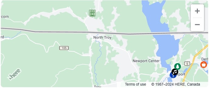
No @purplepoppy the border isn't as straight as it looks on a may. For instance. Take a close look at the border between the province of Ontario & the US.
Poppy, your glasses are wiggly! Many of the states borders are determined by rivers. The Columbia River forma most of the border between Oregon and Washington. At the eastern end it does not because the river goes north quite a bit and the border was intended to be pretty much parallel with the border to Canada. Speaking of which, the Niagara River forma much of the border between Canada and the USA. I wish I could find a good map that shows the geographic formations that form the borders.
Upon migrating westward, we experienced rectification, liberated from the manipulations of colonial opportunists.
The harmonious convergence of four sovereign territories, exemplified by the Four Corners Monument, metaphorically embodies the brilliance and integrity of the American ethos.
This mathematical precision, furthermore, serves as an intriguing psychological war instrumentation, considering the native populations' reputed apprehension towards linear constructs.
The border was intended to be a straight line, but in reality it was surveyed by crews using primitive instruments cutting their way through trees and brush to place stone markers along the border. Officially, the border follows those stone makers, not a perfectly straight line.
Yes from my experience granted I only went through 5 states in my time there but yeah I would say they are. It's nothing alike to us, and the reason is obvious because they only made their roads and states recently. While we've been around a lot longer when it was harder to plan at first with the foresight they had.
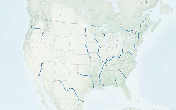
No, very few of the borders between states are straight lines. Many of them following rivers and mountains. Even when the attempt was a straight line, usually a line of latitude or longitude, the surveyor's accuracy in the 1800s (when the border was determined) was not that accurate, and the "straight" border may have curves or bumps in it.
The reason borders were wiggly is because at the time of forming state boundaries and land territory you had to walk the path of least resistance. Once you hit the middle America where things get quite flat it is quite easy to walk a straight line
I think, after the initial colonies, they often went with latitude and longitude lines, at least where there weren't any massive rivers or mountain ranges to make natural barriers. Like the barrier between North and South Korea; the 54th (or is it the 45th) parallel (line of lattitude).
I mean, if you zoom is closely on some areas, you'll notice there is some lopsidedness, especially in the northeast. A lot of those borders were drawn up WAY before we had GPS technology, so they're not gonna be 100% straight. Also, that map you posted ceded part of Minnesota to Canada. As for Europe, I know a lot of your borders are formed by mountain ranges and rivers.
The England/Wales border has been changing for a millennium already depending how much the cartographer had to drink and if he was hired by Longshanks or Llywelyn ap Gruffydd...
Also, where the Severn is kind of meanders a bit...
Borders are created - for the most part- in two ways- the ones that you see that do not run straight are borders that are naturally dictated by local topography; rivers, mouytain rages and such. Straight line borders are usually the result of treaties that have dictrated certain longitudes and latitudes for borders. They are straight.
Surely you know that the borders here in Britain were the results of centuries of territorial fighting from long before these isles were anything like a single country.
The United States though... they didn't set those borders the same way. There was no state-vs-state warfare over who gets what land. It was basically decided by people sitting around tables, so little wonder the lines are a lot straighter.
Yeah there are some states that are wiggly either from a big river like the Mississippi River or mountains and lakes. Mostly the western states of the USA is gave straight line states with little less rivers and lakes and also it was more planned out after the Louisiana purchase when the US bought the land from France.
Haha, yes. Many of the states past the eastern sea board were divided up by people who had never seen the geography without any consideration of the traditional local populations
The borders based on rivers are as wiggly as the rivers were. They've moved, but the borders haven't. Look at the Missippi river and the borders of states it passes by.
 Girl's Behavior
  Guy's Behavior
  Flirting
  Dating
  Relationships
  Fashion & Beauty
  Health & Fitness
  Marriage & Weddings
  Shopping & Gifts
  Technology & Internet
  Break Up & Divorce
  Education & Career
  Entertainment & Arts
  Family & Friends
  Food & Beverage
  Hobbies & Leisure
  Other
Other  Religion & Spirituality
  Society & Politics
  Sports
  Travel
  Trending & News